
How Hancock County Search Starts
Start a Hancock County property search at the West Virginia Property Assessment portal. The Hancock page accepts a street name, an owner name, a full parcel ID, or a map number. It also takes a parcel or a sub-parcel. A street query often returns several parcels along one road. Copy the root parcel ID from the row you want. Then copy the district, map, parcel, and subparcel fields. Those keys travel better than an address does. Treat the lookup as a sequence rather than one box. The assessor links your clue to a parcel and its current roll fields. The County Clerk's Legal Records system confirms deed references. The Sheriff's Tax Office shows ticket status. A map link places the parcel geographically. Each source overlaps a little, yet none stands in for another.
- Search the assessor by street, owner, or full parcel ID.
- Copy the root parcel ID, situs and mailing addresses, appraisal fields, and deed book/page if shown.
- Open the GIS Map or Flood Tool link to view the mapped parcel and screening context.
- Use the parcel components in the sheriff tax portal, then check paid or unpaid status for the relevant year.
- Carry the owner or book/page reference to the County Clerk when the recorded conveyance matters.
Hancock County Assessor Search Fields
The state assessment page offers far more than address and name boxes. Basic search fields cover county, district, owner, street, full parcel ID, map number, parcel, and subparcel. Appraisal and sales filters narrow by land, building, or total appraisal, acreage, and sale dates. They also filter by minimum or maximum sale price. Advanced options add mailing address, legal description, and deed book and page. More filters cover building year and area, structure type, and flood hazard.
| Search field | What it narrows | Useful caution |
|---|---|---|
| Street Name | Properties along a road | Check every matching situs address. |
| Owner Name | Roll entries tied to a name | Try entity names and spelling variants. |
| Full Parcel ID | A root parcel record | Save the full identifier. |
| Map / Parcel / Sub-Parcel | Tax-map components | Use the district with these keys. |
| Legal Description / Deed Book / Page | Document and land-description clues | Confirm with the clerk’s instrument. |
| Appraisal, acres and sale filters | A result range | Sale consideration is not a current appraisal. |
Other controls shape the results themselves. You can set lines per page. The portal can also display the legal description and show a GIS parcel ID. The portal offers a CSV Results link and a View in Property Viewer link. Class and land-use options come from the portal itself. It publishes no full static list of those choices.
Opening the Hancock County Roll
The WV Property Assessment search is the online entry point for these fields. Each returned row carries a full set of details. You get a root parcel ID, current owner, and property address. The row also lists county and district, map and parcel, a GIS map link, and a Flood Tool. Deeded acres, property class, land-use code, and tax class round it out. Building, land, and total appraisal figures complete the picture. Read that as a field inventory rather than a sample result. A live Hancock query supplies the current record. The portal's search interface displays its filters plainly, with no parcel selected. Once a result opens, save its query URL and parcel key. CSV output helps preserve a working list when a street search returns several entries. Use the state interface for Hancock parcels even when the address names a city. Chester, New Cumberland, and Weirton have no separate city assessors or recorders. The municipal label is context only, and county assessment remains the lookup route. Open the Hancock assessor search to review its owner, street, and parcel filters.
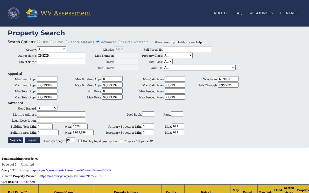
The search form is the discovery step; the result row supplies the parcel reference for everything that follows.
What a Hancock County Result Contains
A returned assessor row gathers identity, location, valuation, and map links in one place. That is where its value lies. The Current Owner column holds the roll's present administrative owner name. Property Address is the situs. An advanced mailing address search may point somewhere else entirely for tax correspondence. District, map, parcel, and subparcel fields make matching the row simple. They tie the row to a ticket or tax map.
| Current Owner | Name shown on the assessment roll. |
|---|---|
| Property Address | Situs address tied to the parcel. |
| Mailing Address | Separate address field for correspondence. |
| Root Parcel ID and map keys | County, district, map, parcel and subparcel identifiers. |
| Appraisal fields | Building, land and total appraisal. |
| Other links | GIS Map, Flood Tool, deeded acres and classification fields. |
The row's inventory has limits. It cannot prove the roll has caught up with a new closing. The GIS link is not a boundary survey. A roll result reveals nothing about every lien, easement, or court claim against the parcel. The assessor's deed book and page field is a bridge to a land record. It is not the deed itself. When the legal transfer is at issue, open the actual instrument in the clerk's system or at the counter.
Hancock County Owner Name Searches
An owner search can surface several holdings under one name. A name is not a unique parcel key, though. Search an individual in multiple forms. Try surname and given name, initials, and a version stripped of punctuation. For land held by an LLC, trust, or estate, try the entity or fiduciary name shown in the assessor record. The assessment interface has an owner name mode. The clerk's grantor and grantee index offers a separate recorded-party trail. Use the address and parcel fields to judge whether two same-name rows describe one person or two. A mailing address may belong to an attorney, a company manager, or an out-of-county owner of record. It never proves anyone lives at the property. When an entity holds title, the owner label names no personal contact. Business filings can identify the entity's registered agent, but that role sits apart from land ownership. That distinction matters in a deed records review.
- Owner of record
- The name carried by the assessment roll for the parcel.
- Situs
- The property’s location address, distinct from tax-mail delivery.
- Root parcel ID
- The durable assessment key that links the roll to mapping and tax references.
Hancock County Deed Search Follow-Up
Once a Hancock County property search turns up a deed book and page, carry that reference, along with the parcel's legal description, to the Hancock County Clerk Legal Records page. CCLIX indexing reaches back to 1979 for deeds and 1971 for mortgages. Instrument images are online from January 2004 forward. Older index entries may therefore list a deed but offer no image. The assigned account and image software carry fees. Public indices and documents can still be inspected free at the clerk's office.
The clerk's counter and microfilm remain the documented fallback for anything the online index lacks. The assessor search is not a title search either. Its owner field can run ahead of a recorded conveyance or trail behind it. Confirm a recent transfer in the deed record itself. Hancock's public pages state no typical update interval. Treat any closing-to-roll delay as unknown rather than assumed.
Hancock County Address and Parcel Clues
Start with an address only when it looks current. A renamed road, a changed street number, or a postal city that misses the municipal line all point the same direction. Swap to the parcel key and legal description. The full root parcel ID outlasts any address string. Its tax-map pieces also let a searcher move between the assessment roll, the GIS map, and the sheriff's tax ticket.
Hancock County sits beside Ohio and Pennsylvania. The narrow river corridor makes city, postal, and county descriptions easy to confuse. The assessor keeps separate property and mailing address fields. The state result adds direct GIS and Flood Tool links. Check the district or corporation field and the recorded legal description rather than treating a ZIP code as proof of a boundary. A postal city is not a boundary.
Choose a Hancock County Search Key
Match the search key to the evidence in hand. An address is easy to remember. An owner name can surface more than one holding. A full parcel key gives the cleanest match across county systems. The comparison below only finds the row; the clerk, sheriff, or GIS route still answers the deeper question.
| Search Key | Best For | Where It Works | Watch Out |
|---|---|---|---|
| Street address | Find a situs or a group of road-side parcels. | WV Property Assessment search | Old numbers and postal labels may differ. |
| Owner name | Find roll entries associated with a person or entity. | Assessment search; CCLIX for recorded parties | Variants, estates and same names need checking. |
| Full parcel ID or map key | Match one assessment parcel across services. | Assessment, GIS and sheriff tax portal | Preserve district, map, parcel and subparcel. |
Not a title search. A Hancock County property search assembles public roll and index clues; it does not establish clear title or legal boundaries. Review the recorded instruments with a title professional, and ask a licensed surveyor to locate a disputed line.
Hancock County Results, CSV and New Parcels
Output controls matter when an address floods the results. The assessment interface can raise lines per page, include a legal description, display the GIS parcel ID, and produce CSV Results. Save the query link with your notes. Keep the root ID beside any exported row. A later recheck then depends less on a remembered street spelling or a changed postal label.
A split or new parcel may lag. Parcel changes wait for county submission and the yearly state update. State tax-map products then catch up. For a recent division, compare the recorded deed or plat with the current assessment entry and map. An empty new row is not proof of failure. Lean on the legal description and clerk reference while the roll catches up.
Carry One Identifier Across County Systems
When the assessor search returns a likely parcel, record the whole displayed parcel identifier. Note the district, map, parcel, and subparcel parts too. The tax portal accepts lookups by those components. The assessor result can also open the GIS view. Similar street names or mailing addresses can appear in more than one community. The full key prevents that confusion. Hancock County publishes no digit-by-digit guide to its parcel-number convention. Read the field labels on screen instead of decoding the number yourself.
Next, look at the assessor's current owner and property address. Compare them with the question you are actually asking. A mailing address may belong to an owner living elsewhere. It is not a second situs address. To learn who conveyed a parcel or when a transfer was recorded, take the owner name and legal description to the County Clerk's deed index. A tax ticket shows whether the selected year is paid or unpaid. It never proves a transfer of ownership.
A blank assessor result is not the end. Try a shorter street-name term. A known owner name or the map number may work instead. Check that the search is set to Hancock County. Filters such as property class or tax class can narrow a result. This can happen without your noticing. Recent division or combination of land can change the key the current roll uses. Ask the Assessor which current parcel matches an older deed description. A blank search is not evidence that no county record exists.